State Borders
The UAE is one of the smaller countries in the Middle East, located in the eastern region. It is a mostly desert stretch of land surrounded by the Persian Gulf and the Arabian Sea, and shares borders with Oman and Saudi Arabia.
It enjoys a unique strategic location. It borders the Gulf of Oman and overlooks the southern approach to the Strait of Hormuz, a vital transit point for world oil.
The land borders of the UAE total 867 kilometers, 410 with Oman and 457 with Saudi Arabia. Its coastline is 1,318 kilometers long.
Its maritime claims include 12 nautical miles (nm) territorial sea; 24 nm contiguous zone; 200 nm exclusive economic zone; and a continental shelf that extends out 200 nm, or to the continental margin.
Border Disputes
As in other countries of the Middle East, the UAE borders were not always clearly demarcated. Part of the border with Saudi Arabia caused a running dispute between the two countries.
The Jeddah Treaty of 1974, the ‘Agreement on the Delimitation of Boundaries,’ has failed to bring an end to this problem. It gave Saudi Arabia a corridor to the Gulf and the UAE six villages (including al-Ain) and a desert area in the south.
Saudi Arabia dropped its claim to the Buraimi oasis region. At the same time, the UAE relinquished a 25 kilometer-long strip of land linking it to Qatar and gave up some 80 percent of the Shayba oilfield resources in south-eastern Saudi Arabia. Saudi Arabia ratified the treaty in 1993, but the UAE has yet to follow suit.
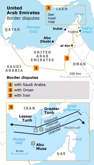
The 30-year dispute was reignited in 2006. Saudi Arabia objected to a natural gas pipeline from Qatar to the UAE because it crossed into Saudi territorial waters. It also disputed maps published by the UAE that depict the country’s border extending west all the way to Qatar.
In the summer of 2009, Saudi Arabia restricted trucks’ movement and barred UAE citizens from entering Saudi Arabia using a new UAE ID card that showed the UAE’s new maps.
The dispute finally escalated into a naval clash between the two sides in March 2010.
The border with Oman also remains officially unsettled, but the two governments agreed to delineate the border in May 1999.
Since then, the UAE has constructed a fence along its borders with Oman and Saudi Arabia.
The UAE also has an ongoing dispute with Iran over three islands in the Persian Gulf – Abu Musa and Greater and Lesser Tunb.
The strategically located islands have been under contested Iranian sovereignty since 1971 when it took control of them militarily. The UAE’s attempts to resolve the issue have been routinely rejected by Iran.
In 1994 the UAE attempted to go to the International Court of Justice in The Hague for arbitration, but Iran refused.
The UAE has a friendship treaty with the United Kingdom, signed in 1971. Fearing Iran’s rising power in the Gulf, the UAE signed a defense treaty with the United States in 1995.
Other defense and military cooperation treaties were signed with Italy and France in 2009 and the United Kingdom in 2010.
Geography and Climate
According to the CIA’s World Factbook, the UAE has a total surface area of 83,600 square kilometers, comparable to Austria or Azerbaijan. The UAE can be divided into three geographical zones: a flat, low-lying, barren coastal plain; rolling dunes that stretch from the coast into the expanse of a vast desert wasteland that blends into the Empty Quarter (al-Rub al-Khali), the world’s largest sand desert; and a rugged mountain range, shared with Oman, in the north and east. While parts of these mountains are bare, other parts, such as the Jabal al-Akhdar, have vegetation. The UAE’s highest point is the top of Jabal Yibir, at 1,527 meters.
The UAE lies within the northern desert belt of the Arabian Peninsula, known for its scarce and unpredictable rainfall, high temperatures and humidities, and prolonged periods of sunshine (about eight hours per day in winter and 11 hours in summer). The UAE has a harsh desert climate, generally hot and humid in the summer but cooler in the mountainous regions, such as the Hajar al-Gharbi Mountains. July and August are the hottest months when average maximum temperatures exceed 48 °C on the coastal plain. During the late summer months, a humid south-east wind called sharqi (‘easterly’) makes the summers too humid for comfort, but there is usually a slight drop in temperature in the evening.
Temperatures and Rainfall
In January and February, the average minimum temperature ranges between 10 °C and 14 °C. From December to March, it is mostly warm and sunny. Winter typically brings very little or no rain, except for occasional showers and downpours that can cause flash floods in wadi beds. The average annual rainfall in the UAE is 100 millimeters, though this varies from year to year and between regions.
Like the broader region, the UAE is prone to occasional violent sand and dust storms. These are caused by strong northerly and north-westerly winds known as shamal (‘north wind’). Shamals can be very hazardous and disruptive, affecting health and reducing visibility.
Dubai Creek
The main cities of the UAE are favored with creeks (khors), which are deep saltwater inlets that run from the sea into the city. The creeks of UAE coastal cities served as the basis for the fishing and pearling industries that defined the local economy until modern times.
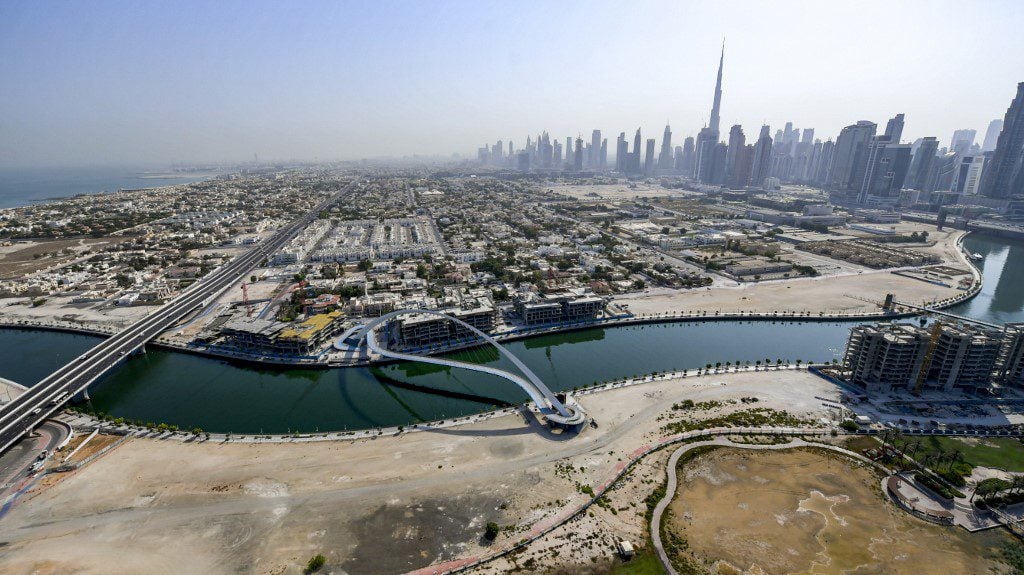
The most famous of these is Dubai Creek (Khor Dubai), which, in ancient times, extended all the way to the city of al-Ain and was called by the Greeks the River Zara. The creek divides the city into its two older sections: Deira and Bur Dubai (where a branch of the Bani Yas tribe, migrating from Abu Dhabi, settled in 1833, to become later the Al Maktoum dynasty, the ruling family of Dubai). Dredging in the 1950s was critical to the emergence of Dubai as a major modern port and trade center (Sharja’s creek silted up at about the same time and became a backwater).
The creek served as a waterway and sheltered port for trade, fishing, pearling, and piracy, helping Dubai grow into a major shipping and commercial center. The distinctive local sailboats, known as dhows, crisscrossed the waters of the Persian Gulf, Arabian Sea, and the Indian Ocean all the way to India and the East African coast, carrying goods and merchandise back and forth. After the collapse of pearling and the country’s increased strategic importance, the creek was transformed into a modern waterway. This was inaugurated in 1955 by construction and dredging projects to widen and deepen the creek to accommodate larger sea-going vessels and build breakwaters and docks to facilitate the loading and unloading of ships. Several bridges over the creek now connect the two parts of Dubai, the Al Maktoum Bridge, the first of which was built in 1963. The creek continues to play an important economic role through trade and tourism, while most shipping activities now take place at much larger ports, such as Port Rashid and Jebel Ali Port.
Biodiversity
The UAE has four main ecosystems: desert, maritime, freshwater, and montane. The desert habitat falls within the arid tropical zone. It supports varying amounts of sparse seasonal vegetation, with less of it in the south, which encompasses the north-western tip of the Empty Quarter, the world’s largest sand desert. The desert environment is undergoing significant changes due to its massive forestation projects and the spread of desert farms.
The maritime habitats are part of the Gulf and Arabian Sea zones, both of which have important ecosystems, including islands, coral reefs, seagrasses, intertidal areas, salt marshes, khors (tidal inlets), and mangroves. Permanent freshwater sources are scarce and are found mostly in the gorges of wadis (valleys) in the mountains and in sabkhas (salt flats) and artificial lakes, which form wetland ecosystems.
The Hajar Mountains, located in the eastern UAE, act as rain catchers. The precipitation replenishes groundwater and feeds freshwater habitats of pools, wadis, and springs, where wildlife such as dragonflies, toads, and fish can be found. The mountains themselves attract endangered wildlife such as the Arabian leopard and the Arabian tahr (an ungulate related to goats).
Natural Resources
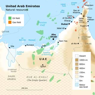
The UAE’s primary natural resources are petroleum and natural gas. More than 90 percent of these resources are found in the emirate of Abu Dhabi. Natural freshwater is extremely limited and has been critically overexploited. Underwater aquifers fell by 10 meters between 1977 and 1984, resulting in increased salinity levels and seawater intrusion into groundwater. The country gets most of its water from desalination plants (thus, seawater may be counted as a natural resource). Increasing amounts of solar energy are being generated, as in the new, environmentally friendly city of Masdar, which is still under construction in Abu Dhabi.
In addition to petroleum, the UAE extracts rock and sand, mostly for use in construction. Limestone, sand, marl, and gypsum are used to make cement, and there is small-scale mining of chromite in Fujairah.
Land Fertility
Given the desert climate of the country, the arable land in the UAE is estimated to be 0.8 percent. A little over a quarter is irrigated. The area used for permanent crops is 2.4 percent, most of it artificially irrigated (Worldbank data).
The UAE has been working to develop its agricultural potential with research in new irrigation and fertilization technologies.
Approximately, 16 percent of the UAE’s people in 2010 live rural and semi-nomadic lives. They support themselves through various agricultural activities.
Despite the high aridity, the country has developed thriving agriculture, leading to year-round self-sufficiency in some vegetable crops. It also has growing meat and dairy industries.
The UAE has 42 million date palm trees, the largest concentration of palm trees in the world.
The country has several oases in the desert southwest and southeast of Abu Dhabi. These offer adequate underground water sources for human settlement and limited agriculture. The largest of these is the Liwa Oasis, located at the Empty Quarter’s edge, near the border with Saudi Arabia.
Environmental Issues
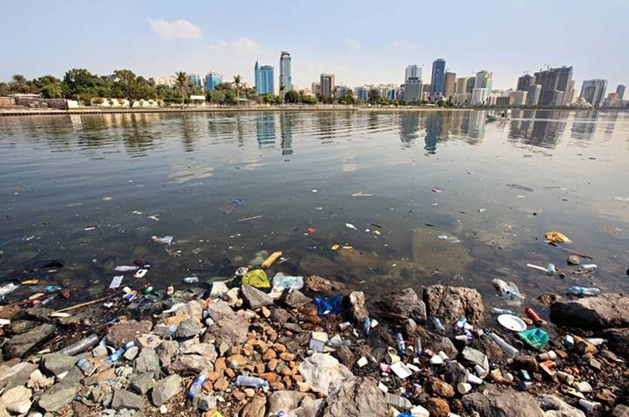
Several major environmental issues face the UAE: first, the lack of natural freshwater, compensated for by water desalination (and the treatment of sewage water for use in irrigation). Second, desertification, which the country has been trying to counter through major afforestation and greening projects. Third, marine and coastal pollution from oil spills, sewage, and other human activity. Fourth, air and soil pollution resulting from the country’s population’s growth (and its wasteful habits), urbanization, infrastructure and transportation, and industry. Fifth, the encroachment of built-up areas and human activity on marine and desert environments’ fragile ecosystems. The many artificial islands and their commercial developments and desert tourism and recreation using motorized vehicles are of major concern to environmentalists.
The UAE is a party to several international environmental agreements, including the Kyoto Protocol, the United Nations Convention to Combat Desertification, the Convention on International Trade in Endangered Species of Wild Fauna and Flora, and the Convention on the Prevention of Marine Pollution by Dumping of Wastes and Other Matter. It has signed but not ratified the United Nations Convention on Law of the Sea.
Environmental governance in the UAE began in 1975 when the Ministry of Health set up the Higher Environmental Committee, later replaced by the Federal Environmental Agency (FEA) in 1993, and by the Ministry of Environment and Water in 2009; this was followed by the establishment of the Environmental Research and Wildlife Development Agency (ERWDA) in 1997, renamed the Environment Agency – Abu Dhabi (EAD) in 2005; it describes its mission as ‘protecting and managing biodiversity, providing a clean environment and promoting Sustainable Development in the Emirate of Abu Dhabi’ (EAD, 2009). Other governmental agencies include the Dubai Coastal Zone Monitoring Programme and the Environment and Protected Areas Authority – Sharja. There is also some nongovernmental and voluntary environmental organization, such as the Emirates Environmental Group (EEG).