State Borders
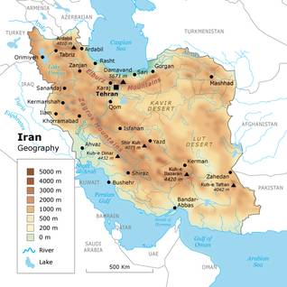
Iran borders Pakistan, Afghanistan, and Turkmenistan on the east, Iraq on the west, and Turkey, Armenia, Azerbaijan, and the Azerbaijan-Nakhichevan exclave on the north. To its south Iran borders the Gulf of Oman and the Persian Gulf, and to its north the Caspian Sea (the largest lake on earth, with an estimated surface area of 371,000 square kilometres).
The Aras (also known as Araks) River lies along the border with Iran and Azerbaijan. In the Treaty of Turkmenchay (1828) the river was chosen as the border between the Russian and Persian empires. In 1963 Iran and the Soviet Union began construction of the Aras Dam, which was inaugurated in 1971.
Sovereignty over the waterway Arvand-Rud (or Shatt al-Arab, in Arabic) has for centuries been a source of conflict between various Iranian and Iraqi states. The 200-kilometre-long waterway, of which the last 80 kilometres form the frontier between Iran and Iraq, is strategically important for both countries, because Basra, the only Iraqi port with access to the Persian Gulf, lies upstream, and some of the major oil installations of both countries are situated near the waterway. Territorial claims between Iran and Iraq were among the causes of the Iraq-Iran War.
Geography and Climate
The territory of Iran comprises 1.648 million square kilometres – double the size of neighbouring Turkey and three times the size of France – of which 1.636 million square kilometres is land and 12,000 square kilometres water.
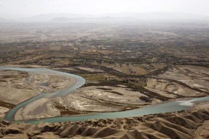
Iran is a mountainous country. The Zagros Mountains bisect the country from north-west to south-east. Many peaks in the Zagros exceed 3,000 metres above sea level. Rimming the Caspian Sea are the Alborz Mountains, which are narrow but high. The volcanic Mount Damavand (5,671 metres), located in the centre of the Alborz, is Iran’s highest peak; on clear days, it can be seen from Tehran.
The central portion of Iran is referred to as the Central Plateau. The eastern part of the plateau is covered by two salt deserts, the Dasht-e Kavir (Great Desert) and the Dasht-e Lut (Barren Desert).
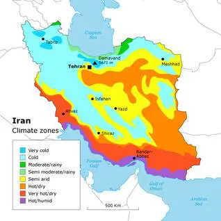
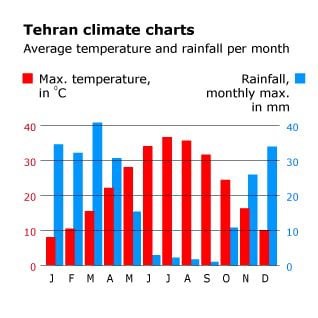
Iran’s climate varies considerably from region to region. In the north-west, winters are cold, with heavy snowfall and subfreezing temperatures during December and January.
Spring and autumn are relatively mild, and summers are dry and hot. In the south, the winters are mild and the summers very hot, with an average daily maximum temperature in July exceeding 38 °C in some areas.
Temperature and precipitation also vary with elevation, as winds bring heavy moisture from the Persian Gulf. Iran’s climate is mostly arid or semiarid and subtropical along the Caspian coast.
Natural Resources
Iran’s natural resources are extensive and include petroleum and natural gas, coal, chromium, copper, iron ore, lead, manganese, zinc, and sulphur.
Land Fertility
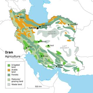
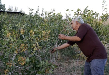
Mountain ranges, deserts, and wasteland cover about half of Iran’s total land area. An estimated one-third of the country’s total surface area is suited for agricultural production.
Almost 12 percent of Iran’s territory is under cultivation (arable land, orchards, and vineyards), but less than one-third of the cultivated land is irrigated, and the rest is cultivated by dry farming.
Environmental Issues
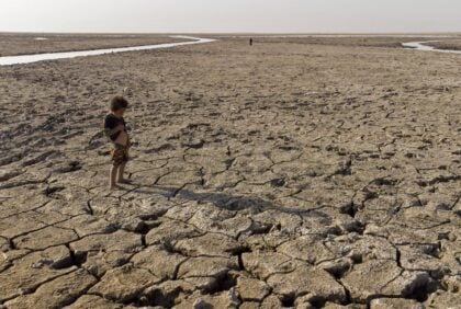
Iran faces various serious environmental problems, such as limited natural freshwater resources, soil erosion, deforestation, and overgrazing. Industries and vehicle emissions have led to increasing pollution. Air pollution is not only causing health problems but also damaging historical sites such as Persepolis. Air pollution in Tehran poses a major urban environmental threat and far exceeds the standards set by the World Health Organization (WHO). On some days in Tehran smog alerts warn older people to stay indoors, and schools close because of the dangerously high level of air pollutants.
Excessive consumption and waste of water has become a critical problem. Officials of the Iran Water Resources Management Company once admitted that Iran’s per capita water consumption in metropolitan areas is higher than the average rate recorded for most developed cities in other parts of the world. Long-term drought and a growing number of floods are creating new environmental-planning needs.
Earthquakes
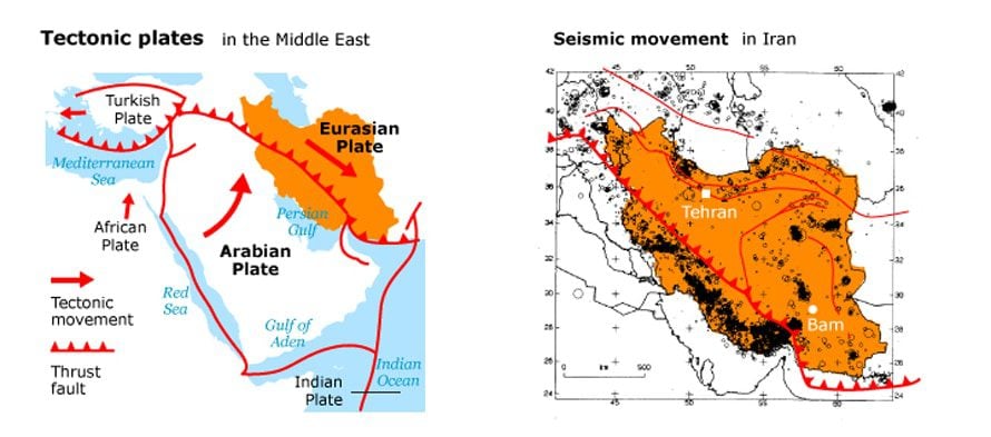
Droughts, floods, dust storms, and sandstorms – Iran faces many natural hazards. Due to its position in the geologically active Alpine-Himalayan belt, earthquakes are among Iran’s most dangerous natural hazards. The last great earthquake, on 26 December 2003, measured 6.6 on the Richter Scale and destroyed much of the city of Bam, in south-eastern Iran, and about 80 percent of the pre-Islamic citadel of Arg-e Bam. The death toll was estimated officially at 41,000, and more than 45,000 people were displaced.
Biodiversity
Variations in topographic relief and climate mean that Iran has five biodiversity zones: Irano-Turanian Plain (ITP), arid and semi-arid plains and desert; Irano-Turanian Mountains (ITM), arid and semi-arid mountains; Zagrosian (Z), semi-arid Zagros mountains; Hyrcanian (H), semi-humid and humid Arasbaran (in East Azerbaijan) and Hyrcanian mountains (on the Caspian Sea) and Caspian plain; and Khalijo-Ommanian (KO), dry southern coastal plains with high humidity.
About 8,200 species of plants, 500 species of birds, and 160 species of mammals can be found in Iran. The wetlands in the Caspian and Persian Gulf region are of particular importance globally; migratory birds use them on their way to and from Africa or the Indian sub-continent.
Energy

Iran has extensive reserves of oil and natural-gas. With an estimated 157 billion barrels of crude oil – about 13.1 percent of the world’s proven reserves – Iran ranks second after Saudi Arabia and is followed by Iraq. Iranian natural-gas reserves are estimated at more than 32 trillion cubic metres, equalling 18 percent of the world’s total natural-gas reserves, ranking second in the world, after Russia.
The fossil-fuels sector is controlled by two large public companies, the National Iranian Oil Company (NIOC) and the National Iranian Gas Company (NIGC), both controlled by the Ministry of Oil, which itself falls under the Supreme Energy Council (SEC).
Iran is an important actor in the world petroleum market, exporting 65 percent of its crude oil to Asia, Europe, and Africa.
Compared to its peak output of 6.6 million barrels per day in 1976, however, Iranian oil-industry output has slowed considerably, averaging about 4 million barrels per day in 2005 and 2006, and about 3.2 million barrels a day in early 2012. Iran is planning to develop the oil industry in the Caspian Sea in order to increase its crude oil production, but Iran’s claim of a 20 percent share of Caspian oil is being disputed by Russia, Turkmenistan, Azerbaijan, and Kazakhstan.
In 2006 natural-gas production was 110 billion cubic metres, providing nearly half of Iran’s energy needs. With the government planning substantial investments in natural-gas exploitation, its share in energy consumption is expected to rise quickly. Much of Iran’s natural-gas reserves is believed to remain untapped.
While Iran is an important crude-oil exporter, its refinery capacity provides only 60 percent of domestic needs. Iran spent USD 4 billion dollars on fuel imports in 2005 alone. Because consumption of petroleum products has been growing rapidly, at a rate of 8 percent per year since 2000, the need for imported oil products will only increase.
Because petroleum products in Iran are heavily subsidized, the increasing importation of those products is a heavy burden on the state’s budget. Petrol is a major worry: in 2006 more than 45 percent was imported. When the government announced the rationing of petrol, riots broke out in the summer of 2007. Nevertheless Iran has tried to reduce its dependence on foreign refined petroleum products by reducing petrol subsidies to its citizens. Iran’s imports of petrol declined from 130,000 barrels per day in 2009 to 50,000 barrels per day in 2011.
Electricity consumption has grown by a factor of five since 1990. Iran’s electricity consumption in 2000 stood at 88.64 billion kWh and reached 199.8 billion kWh in 2011. Because of further population growth and intensifying industrialization, Iran seeks to increase its electricity capacity by developing hydroelectric stations, conventional coal- and oil-fired stations, wind-powered and geothermal plants, solar-thermal plants, and nuclear power plants.
Latest Articles
Below are the latest articles by acclaimed journalists and academics concerning the topic ‘Geography’ and ‘Iran’. These articles are posted in this country file or elsewhere on our website: