State Borders
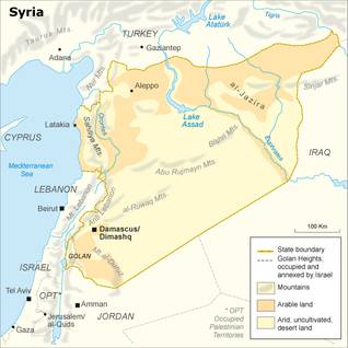
Syria’s coastline measures 183 kilometers. Syria’s land boundaries stretch across 2,253 kilometers. Its borders with Turkey are 822 kilometers, with Iraq 605 kilometers, and with Jordan and Lebanon 375 kilometers. Its border with Israel, which is officially still at war, is only 76 kilometers.
Syria’s surface equals 185,180 square kilometers, including the 1,295 square kilometers of Israeli-occupied Golan Heights.
The country is seventeen times larger than its neighbor Lebanon, eight times the size of Israel and twice that of Jordan.
But Syria is dwarfed by its neighbors in the north and east: it is only a quarter of Turkey’s size, and it is 2.5 times smaller than Iraq.
Environmental Issues
Unless stated otherwise, information in this chapter is provided by Strategy & National Environment Action Plan and by The State of the Environment and Development in the Mediterranean, 2009)
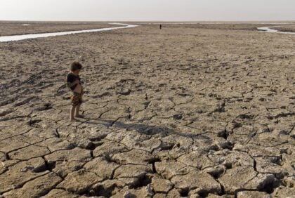
Syria has many environmental problems. These include deforestation, overgrazing, soil erosion, desertification, water pollution from the dumping of raw sewage and wastes from petroleum refining, and inadequate potable water supplies. Water shortages, exacerbated by population growth, industrial expansion, and water pollution, are a significant long-term economic development constraint. Dust storms and sandstorms are natural hazards in desert areas.
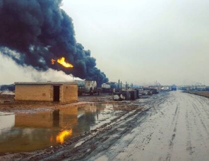
Air pollution is extremely high in Syria’s big cities. Average carbon monoxide concentrations vary between 2 and 20 ppm due to the dense traffic (allowable limit specified by World Health Organization: 9 ppm). CO2 emissions amounted to 3 metric tons per capita (World Bank 2009). Furthermore, public transport is often inadequate. For these and other reasons, the decision was made to build a metro.
The European Union partly finances the estimated cost of one billion euro (using the European Investment Bank, EIB, and its Facility for Euro-Mediterranean Investment and Partnership, FEMIP), as part of a package to help modernize Syrian cities (urban renewal, urban traffic, and transport, public tourist facilities, wastewater, and solid waste management). The preliminary studies concerning the subway were to be finished by 2009, a tender issued in 2010, and the first line, the ‘Green Line,’ running east-west, finished by 2016. In July 2010, plans for the metro were updated.
The Strategy & National Environmental Action Plan (sponsored by UNDP and World Bank) states: ‘For a long time, Syria was renowned for its very diverse geographic and climatic features, which provided a variety of environments suitable for a wide range of plant and animal species, and great genetic diversity within these.
However, due to natural habitat destruction, accompanied by population growth and associated human activities, urban development, and agricultural expansion, many categories of biological and genetic resources are being depleted and endangered.’ Whatever the subject (water resources and quality, air quality, biodiversity, wastes), the report is deeply disheartening. Since it was published (2003), some projects (reforestation, wastewater treatment, sustainable use of resources, protected areas) were initiated, and some progress was made, but finances are a permanent problem.
Syria depends for 43 percent on the Euphrates’ water, which it has to share with Turkey and Iraq. Irrigation water accounts for almost 90 percent of Syria’s water demand – and yet, only a small portion of the arable land is irrigated. The UNEP State of the Environment and Development in the Mediterranean report (2009) sums up the main obstacles to the implementation of water demand management in Syria: lack of coordination between ministries; contradictory policies: the assistance policy for farmers to buy modern irrigation systems is not, for example, coordinated with the pricing policy for irrigation water; inadequately skilled personnel; drinking water wasted due to a lack of public awareness.
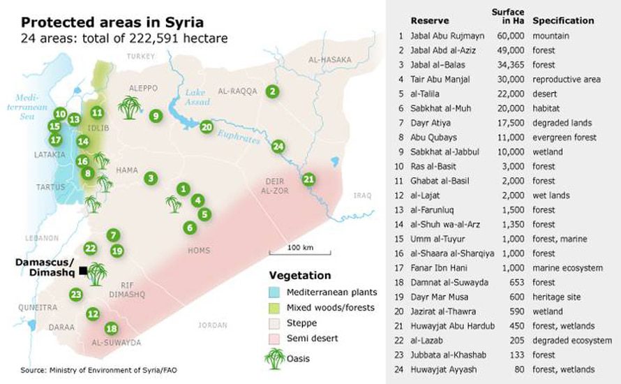
Among the positive results is the fact that there are now 24 protected areas, including the Abu Qubays PA (Protected Area) in central north-western Syria (Hama governorate), the Furunluq PA in the north-western coastal region (Latakia governorate), and Jabal Abd al-Aziz PA in the north-east (al-Hasaka governorate).
The forecasts, however, are not very positive, if only because a rise in temperature and a decrease in rainfall is projected, thus increasing the risk of droughts like those Syria experienced in recent years.
Geography and Climate
Syria has a narrow coastal plain that runs along the Mediterranean Sea from north to south. North of Tartus, the mountains plunge directly into the sea. To the east, the Ansariya mountain range borders the coastal plain from north to south. The mountains have an average width of 32 kilometers. They reach their highest point (1,562 meters) east of Latakia. On their eastern flank runs the Ghab Depression, a 64-kilometer long valley where the Orontes River (Nahr al-Asi) flows northward to Turkey and into the Mediterranean Sea.
The Anti-Lebanon Mountains (Jibal Lubnan Al-Sharqiya) mark Syria’s border with Lebanon. The average height of this mountain chain ranges from 1,800 to 2,100 meters. Its highest point is Mount Hermon (Jabal al-Shaykh), at 2,814 meters. The Abu Rujmayn chain prolongs the Ruwaq Mountains that run more or less parallel to the Anti-Lebanon Mountain range, though somewhat to the east. In the extreme south-east, Mount al-Duruz rises to 1,800 meters. The Bishri Mountains stretch north-eastward across the central part of the country.
The rest of the country is desert-like, with mountainous terrains. When there is sufficient rainfall, the Syrian Desert turns into green pasture suitable for grazing. The Hawran Plain in the southwest, between Mount Hermon and the Jordanian frontier, is rock-strewn yet fertile. The only navigable river and main water source are the Euphrates, which flow south-east across the north-eastern part of Syria from its source in the Turkish Taurus Range. Its tributaries are the Nahr al-Balikh and the Nahr al-Khabour. In 1973, an artificial lake (Lake Assad) was created when a dam was erected in the river near al-Thawra; it provides water for irrigation purposes and drinking water for the inhabitants of Aleppo.
Climate
The coast and the western mountains have a Mediterranean climate; there is hardly any rainfall from May to October. In the summer, the average temperature is 32 ºC, but it is cooler in the mountains. The winters are mild, with temperatures around 10 ºC. The inland regions have a more continental climate, with hotter summers and colder winters (Eastern Syria is part of the vast Arab Desert). In the mountains, snow and frost are not uncommon in the winter. Once or twice a year, sand-bearing winds (khamsini) raise a wall of dust to 1,500 meters high.
Biodiversity and Natural Environment
Syria’s vegetation can hardly be called rich, as its soil is extremely arid. The only fertile soils are to be found along the rivers’ banks and – astonishingly enough – in the rock-strewn south-western plain called Hawran. According to the Ministry for the Environment, 45 percent of the lands consist of pastures, 32 percent of fertile lands, 20 percent of arid lands, and only 3 percent of forests (compared to 32 percent at the beginning of the 20th century).
(See Strategy & National Environmental Action Plan For The Syrian Arab Republic (SNEAP), 2003)
State of the environment
Syria’s environment is in a dire state: deforestation, overgrazing, soil erosion, desertification, lack of (drinking) water, water pollution from raw sewage, and industrial waste (like petroleum refining waste) are just a few of the problems. The SNEAP report states: ‘For a long time, Syria was renowned for its very diverse geographic and climatic features, which provided a variety of environments suitable for a wide range of plant and animal species, and great genetic diversity within these. However, due to natural habitat destruction, accompanied by population growth and associated human activities, urban development, and agricultural expansion, many categories of biological and genetic resources are being depleted and endangered.’
Reports are disconcerting regarding water resources and quality, air quality, biodiversity, and waste. Since 2003, some projects (reforestation, wastewater treatment, sustainable use of resources, protected areas) have been initiated. However, little progress has been made. Finances are a permanent problem. From 2003, environmental issues have been dealt with by officials of the Ministry of Local Administration. In April 2009, a new Ministry of Environment was established. But the work to protect the environment conflicts with the interests of the industrial sector.
One of the positive results is that there are now three protected areas: the Abu Qubays Protected Area in central north-western Syria (Hama Governorate), the Farunluq Protected Area in the north-western coastal region (Latakia Governorate), and Jabal (Mount) Abd al-Aziz Protected Area in the north-east (al-Hasaka Governorate).
Yew, lime, and fir trees grow in what is left of the forests on the mountain slopes. Scrubs and scrubby underbrush cover many slopes. Trees do not grow on the steppe, except for some sparsely distributed hawthorns. In early spring, a variety of (flowering) plants cover the land. From June, however, the weather is too dry for plants to survive.
Wildlife
There are not that many wild animals left. Some wolves, hyenas (endangered species), foxes, badgers, wild boar, and jackals still live in remote areas. There are also deer (endangered species), bears, squirrels, gazelles, and jerboas (nocturnal rodents). Birds are relatively rare. Syria is on the route of migrating birds. Still, according to the SNEAP report, ‘as a consequence of natural habitat destruction, due to the population growth and associated human activities, urban development and agricultural expansion, many categories of biological and genetic resources are being depleted and endangered.’ Many animals – including the camel and the wild goat – have become endangered species.
Natural Resources
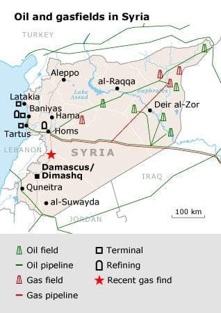
Among Syria’s mineral resources are oil, gas (both reserves are small), phosphates, chrome and manganese ores, asphalt, iron ore, rock salt, marble, gypsum, and hydropower.
Vegetal resources include olive trees, sumac, pistachio, laurel, and mulberry (for silkworm breeding).
Due to deforestation (see Biodiversity), wood is no longer an important natural resource.
Land Fertility
Only a third of the surface consists of fertile land (32 percent) or forests (3 percent). Pastures form 45 percent of the land, where there is extensive cattle breeding. This percentage includes the Syrian Desert, providing sufficient rainfall (see the Strategic & National Environmental Action Plan). Arable land covers 25 percent of the surface, located in the north-western part of the country and along the rivers Euphrates and Orontes (al-Asi). Another fertile region is Hawran, close to the Jordanian border in the south.
A 2003 Food and Agriculture Organization (FAO) report states: ‘The agricultural sector in Syria uses up to 85 percent of all the available water resources in the country (FAO-MAAR, 1999). Irrigated agriculture has increased steadily in Syria over the last decades, almost doubling since 1985. (…) Total expenditures for irrigated agriculture accounted for almost 70 percent of all agriculture expenditures (Sarris, 2001).’
Yet the percentage of irrigated land remains low: ‘From the 18.5 million hectares of total lands of the Syrian Arab Republic, cultivated land extends over an area of 5,484,000 hectares, of which 1,213,000 is irrigated land (22 percent), 3,655,000 hectare is rain-fed land (67 percent), and 616,000 hectare is fallow land (11 percent) (FAO-MAAR, 2001).
Irrigated lands are not distributed evenly across the country, and most concentrate along the Euphrates River, in the coastal areas, and the central regions. The irrigated holdings’ size is substantially smaller than the size of the rain-fed holdings and varies distinctively across regions (governorates). At the national level, the average holding size is 9,2 hectare and for irrigated farms is 3,6 hectare.’ (See FAO, Syrian Agriculture at the Crossroads, 2003)
Syria suffered from harsh droughts between 2007 and 2010. Even though some rain fell in 2010, the harvest failed again in that year.
The northeastern part of Syria is considered extremely vulnerable by the World Food Program. The drought has had a serious impact on the nutritional status and livelihoods of farmers and herders.
Nature Reserves
24 areas are officially listed as Protected Areas (PA’s) or Main Biodiversity Biomes, with a total of 222,591 hectare. Their size and nature vary from the 60,000 hectare mountainous pistachio forest of Jabal Abu Rujmayn (or Abou Rojmen) in central Syria (governorate of Homs) to the 133 hectare Jubbata al-Khashab forest (governorate of Quneitra in the south) or some very small National Heritage areas near Damascus.
These Protected Areas ‘require further development, in addition to the establishment of the appropriate administrative and executive plans’, as stated by the Ministry of Environment (see Strategic & National Environmental Action Plan, 2003). Their actual status is unclear. Further plans have been developed for several regions, which address raising awareness of the local population, and training programs for personnel, but they are yet to materialize. Besides these PA’s, there is about 100,000 hectare of Protected Grazing Areas.
Latest Articles
Below are the latest articles by acclaimed journalists and academics concerning the topic ‘Geography’ and ‘Syria’. These articles are posted in this country file or elsewhere on our website: