Introduction
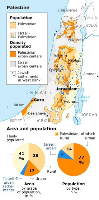
All the large cities in the West Bank are situated on the mountain ridge: from Nablus in the north (population 143,235), via al-Bireh/Ramallah (population 77,183; both cities have merged), East Jerusalem (al-Quds al-Sharqiya; population 251,043), and Bethlehem (Bayt Lahm)/Beit Jala (Bayt Jala)/Beit Sahour (Bayt Sahur) (population 57,433), to Hebron (al-Khalil; population 195,733) in the south. Jericho (Ariha; population 21,411) lies in the Jordan Valley. The medium-sized cities of Tubas (population 19,471), Jenin (population 44,987), Tulkarm (56,984 inhabitants) and Qalqiliya (population 48,197) are located on the border with Israel in the north and west. However, more than half of the Palestinians (about 60 percent) do not live in cities but in the 430 villages scattered across the countryside.
In the Gaza Strip, Gaza City (Ghazza; population 532,132) in the north and Rafah (population 147,618) in the south are the largest population centres. In between lies Khan Younis (population 168,880). There are a further nine villages. (Source: Palestinian Bureau of Statistics, 2013)
In Palestine, urbanization is highest in the Gaza Strip (74.3 percent of the population, CIA World Factbook 2011), and it is no coincidence that the Palestinian city with the highest number of inhabitants is situated here. The Gaza Strip is overpopulated, which can be ascribed mainly to the huge influx of Palestinian refugees as a result of the founding of the State of Israel in 1948 (three quarters of the inhabitants are refugees). The population density in the Gaza Strip amounts to 4,505 persons per square km (Palestinian Bureau of Statistics 2012).


